FLASH FLOODING - TAKE ACTION - EVACUATE NOW
HNL Alert from the Oahu Department of Emergency Management
Issued: 02:22 PM 04-10-2026
Incident Type: FLASH FLOODING
Location: Otake Camp
Alert Details: TAKE ACTION - EVACUATE NOW
Extremely dangerous flooding is occurring.
An Evacuation Order has been issued for the following area(s): Otake Camp in Waialua.
Map: https://p.veoci.com/hnlevac
Go to high ground. If trapped, go to highest floor/roof. Flood waters can move swiftly and rise rapidly. Driving into flooded areas is extremely dangerous and may result in injury or death.
Emergency responders are in the area with high water vehicles to notify anyone in the area and assist with evacuations.
The closest shelter location is Wahiawa District Park. View locations and details can be found at https://p.veoci.com/hnlshelter.
It is not necessary to evacuate any other area at this time but residents on the North Shore are encouraged to limit travel to necessary trips only due to flood impacts across the North Shore.
Actions to Take
Take the following protective actions and LEAVE NOW if you are in the evacuation area.
1. Gather family members. Assist neighbors who need help evacuating if you can do so safely.
2. Bring pets if you can locate and secure them quickly.
3. Do not delay to pack or prepare your home. Take only essential items you have ready to go NOW.
4. Alert neighbors who may not have received this message if you are able to do so safely and quickly.
If you cannot evacuate and water is rising in your home, move to a higher floor. If you are trapped, go to the highest level. Stay out of attics without a way onto the roof. Call 911. If you cannot call, signal for help.
LEAVE NOW or go to high ground or the highest floor of your home if you cannot evacuate.
DO NOT walk or drive through moving water or on flooded roadways
Stay out of the area until emergency officials advise it is safe to return.
Call 911 for emergencies only. Do not call 911 for information or non-emergency situations.
Stay Informed
Check alert.hnlalert.gov for updates or monitor local radio and TV stations.
This message will be updated in 4 hours or sooner if the situation changes.
* * * * *
Severe Weather Update: Evacuation Transportation Services Available
HNL Alert from the Oahu Department of Emergency Management
Issued: 02:34 PM 04-10-2026
Severe Weather Update: Evacuation Transportation Services Available
Details
Makaha-Nānākuli: Pick-up along Farrington Hwy between Mākaha Beach Park and Nānākuli Beach Park; drop-off at Nānākuli High & Intermediate shelter.
North Shore (Route 521 – Waialua–Haleʻiwa): Flag down anywhere; service to Weed Circle, then transfer to Route 52 to Wahiawā Transit Center.
Inform the driver you are evacuating.
Stay Informed
Additional updates will be issued as the situation develops or if there are significant changes to the weather forecast. Follow DEM on social media, encourage others to sign up for HNL Alert, and monitor local TV/radio. Help keep lines clear for first responders. Call 911 for emergencies only. Do not call 911 for general information updates.
Learn more about emergency preparedness and how to protect your family at honolulu.gov/dem.
Mahalo and stay safe!
* * * * *
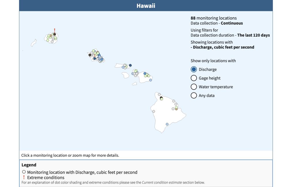
USGS Water Data for the Nation – Hawaiʻi web page.
4/8/26 – PUBLIC URGED TO MONITOR REAL-TIME STREAM CONDITIONS AS STORM APPROACHES HAWAIʻI
News Release from Commission On Water Resources Management, Apr 8, 2026
HONOLULU – With a third storm system forecast to impact the state of Hawaiʻi over the next few days, residents and visitors are reminded that real-time stream data is available as one of several tools they can use to stay informed.
The United States Geological Survey (USGS), in partnership with the State of Hawaiʻi Commission on Water Resource Management (CWRM) and other state and county agencies, provides publicly accessible, near-real-time data on stream level discharge at 88 monitoring locations across the five main Hawaiian Islands through its Water Data for the Nation website:
https://waterdata.usgs.gov/state/hawaii/
To check current conditions:
- Select “Discharge” under the “Show only locations with” on the right of the screen.
- Zoom in to the island and click the gauge location you wish to check.
- Note any locations with a red exclamation point which alerts users to “! Extreme conditions.”
- A color code legend and other information appears below providing users with information.

A stream gauge in Heʻeia Stream, Haiku Valley near Kāneʻohe, Oʻahu.
Stream gauges throughout the islands are typically updated every 15 minutes, offering timely information on rapidly changing conditions during heavy rainfall events.
CWRM advises that real-time stream data is a valuable situational awareness tool, but it should not be used as the sole basis for safety decisions.
Because conditions can change rapidly between updates, the public should rely on official warnings and alerts from the National Weather Service, Hawaiʻi Emergency Management Agency, and county emergency management agencies, as well as using their own judgment when conditions appear unsafe.
For those who wish to receive notifications, the USGS also offers WaterAlert, a free service that sends text or e-mail updates when water levels at selected gauges reach user-defined thresholds:
https://accounts.waterdata.usgs.gov/wateralert/
Residents and visitors can find information on preparations and safety precautions for heavy rain, flooding, strong winds, power outages, large surf and coastal surge on the Hawaiʻi Emergency Management Agency (https://dod.hawaii.gov/hiema/) and county emergency management agencies’ websites.
More weather information is available at: https://www.weather.gov/hfo
# # #
Photos – USGS and CWRM Stream Gauges throughout the Islands (All images/video courtesy: DLNR)