New maps improve Hawaiʻi’s wildfire risk warnings
from UH News March 30, 2025
Scientists at the University of Hawaiʻi have developed new wildfire risk maps to better predict fire danger across the state. Unlike the current Red Flag Warning system, which relies on weather from a limited number of stations, these maps provide a daily, high-resolution look at the most current fire ignition risks statewide.

Latest wildfire risk map up to March 27, 2025. Visit the Hawaiʻi Climate Data Portal website for the most up to date maps.
“This new mapping system gives us a clearer, more detailed picture of wildfire risks across Hawaiʻi. By providing daily updates and a long-term dataset, we hope to improve preparedness and help protect communities from future fires,” said Professor Sayed Bateni of UH Mānoa’s Water Resources Research Center (WRRC) and Department of Civil, Environmental and Construction Engineering.
Publicly available on the Hawaiʻi Climate Data Portal (HCDP), the maps are easy to access and available to communities and emergency responders to alert them to the risk of potential wildfires. Users are able to zoom in to a particular area to assess the current fire risk, and generate customized packages of data to export from the portal. Historical fire risk maps are also available for the past 20 years.
The maps are generated using real-time data obtained from various weather networks across the state including the Hawaiʻi Mesonet. The Hawaiʻi Mesonet currently consists of over 60 advanced weather stations with a total goal of 100 within the next two years. These stations provide valuable weather and climate monitoring and forecasting. The data collected can also be used for water resource management, agriculture, ranching, ecosystem and cultural resource protection and more.
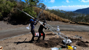
Installation of a weather station on Mariner’s Ridge with the Hawaiʻi Mesonet project.
“It’s all about improving preparedness, especially in light of recent disasters like the devastating wildfires in Los Angeles and the tragic Lahaina fire,” said Tom Giambelluca, retired UH Mānoa professor of Geography and Environment, former director of the WRRC, and leader of the Hawaiʻi Mesonet. “With real-time data on factors like soil moisture, we can better identify areas at high risk for wildfires or flooding.”
Utilizing a well distributed network of weather stations is crucial in Hawaiʻi, where diverse landscapes create extreme climate variability. In West Maui, annual rainfall can differ by more than 140 inches within a mile, highlighting the need for precise, localized data.
“The Hawaiʻi Mesonet is adding high quality weather observations in places where they are most needed,” Giambelluca said.
“This mapping system is a game-changer for wildfire preparedness in Hawaiʻi,” said Clay Trauernicht, assistant specialist in the UH Mānoa Department of Natural Resources and Environmental Management. “Using current data allows us to better anticipate fire risks and take proactive measures to protect communities.”
The Hawaiʻi Emergency Management Agency, Federal Emergency Management Agency and Hawaiʻi State Legislature provided funding to create the fire ignition probability maps.
Bateni, Giambelluca, Trauernicht and Pacific Islands Climate Adaptation Science Center University Consortium Director Ryan Longman will host a presentation in person and online on April 1 at noon to explain how the maps were created, how they predict fire risk and how to access and use the data. Visit the website for more information.